
Louisiana Coastal Services (LCS) is a multidisciplinary law firm, land broker, mapping, and project management company that ![]() assists in making Louisiana coastal projects a success. They have extended expertise in many domains, deep local knowledge, and a modern technology toolkit unlike any other firm. Their services include Regulatory Compliance, GIS Mapping, Grant Management, Litigation, and even Risk Management.
assists in making Louisiana coastal projects a success. They have extended expertise in many domains, deep local knowledge, and a modern technology toolkit unlike any other firm. Their services include Regulatory Compliance, GIS Mapping, Grant Management, Litigation, and even Risk Management.
ArcGIS Online (AGOL) and FileMaker make up the bulk of LCS’s tech stack. AGOL is powerful mapping platform that allows you to host data in the cloud and produce maps than can be embedded into websites. LCS figured out how to display these maps within FileMaker webviewers but quickly realized that wasn’t quite enough. For example, users wanted to be able to click on tracts and open the corresponding FileMaker record. They wanted to be able to change the status of a tract project in FileMaker and have the map update the tract feature’s color to reflect this change. These types of interaction between the web and FileMaker are not trivial. LuminFire was able to provide them with exactly what they required when other developers failed.

The first thing LuminFire did was replace the embedded AGOL maps with maps built natively in the webviewers. These maps still display the same real-time data from AGOL but allow total control over the content and most importantly behavior of clicks, links, etc. FMP URLs were then added to allow map clicks to trigger FileMaker scripts that open relevant records and more.
The next marquee achievement was updating attributes such as project status that exist in AGOL and also exist (and need to be editable) in FileMaker. This involves using script triggers and cURL calls to AGOL’s API to update the data and re-render the maps. The benefit of this feature is that FileMaker users never need to interact directly with AGOL and everyone regardless of whether they are viewing AGOL maps directly or within FileMaker will see the data updated real-time. LuminFire helped setup naming and storage conventions for projects and feature layers in AGOL such that new projects and data can be added to FileMaker with minimal effort. Furthermore LuminFire provided training for LCS staff such that they could add future attribute changes themselves without re-engaging a JavaScript developer.
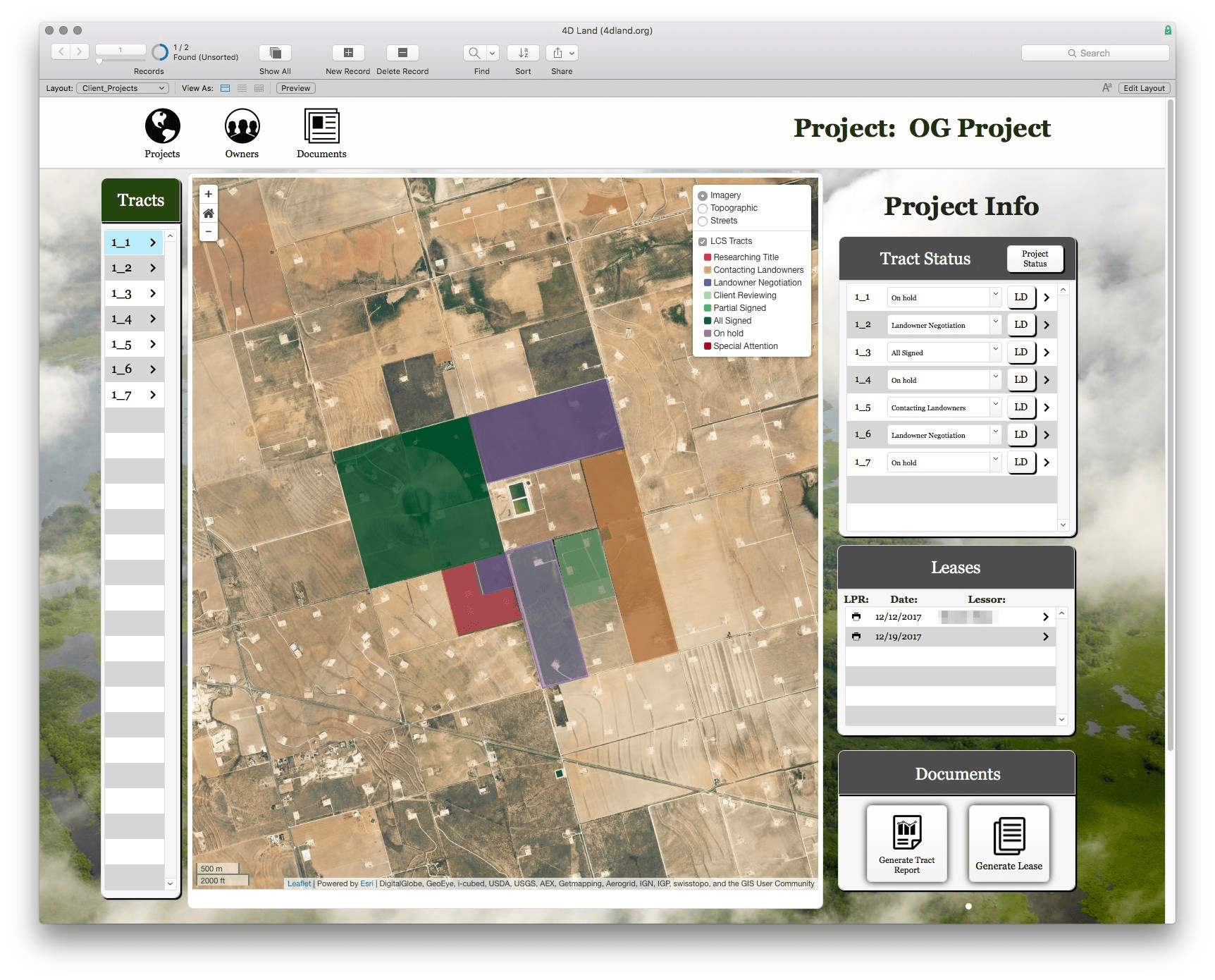
Pictured below: The new map centric project dashboard in the LCS FileMaker App. Changing the tract status in the FileMaker portal at right will update the color and map popup for the tract.
LuminFire GIS solutions help businesses derive value from data through maps, custom applications and spatial analyses. We have developers on staff that are trained in GIS and have the expertise to make your projects a reality. They regularly speak at regional and national GIS conferences as well as contribute to the GIS open source community. FileMaker and WordPress are among the tools we use to integrate GIS solutions.
If your business has a FileMaker app or website that needs to be taken to the next level, we can make that happen. Our expert engineers can build exactly what you need. We build brilliant custom solutions that make your business more effective, productive, and profitable. Contact us to talk about your future solution.

Tim Cimbura – CEO and Software Engineer
Tim is an expert in creating custom business solutions that make businesses more effective, productive, and profitable. He specializes in rapid application development with the Claris platform including FileMaker and WordPress. He also knows Apple macOS technology inside and out.