
Michael Moore and Andrew Walz of LuminFire are presented at #MNGISLIS conference in Duluth, MN in 2016 on topics like JavaScript, MySQL, and Automated Stereogrammetry. The theme of the conference was “Your Geospatial Destiny.” Here’s the full scoop:
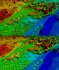 A Comparison of Lidar and Stereo-pair Derived Surface Models – Andy Walz
Thursday, October 27, 2016 from 11:00 a.m. – 11:30 a.m. (Session Number 8)
Lake Superior Room O
How does a surface model derived from stereo-pair imagery stack up against a lidar DSM? Lidar has quickly become the gold standard for elevation data but you might surprised what can be accomplished with high resolution imagery and automated stereogrammetry software like Ames Stereo Pipeline. Lidar data is becoming cheaper and more accessible but it just isn’t available for the majority of our planet. Satellite imagery on the other hand is collected constantly and depending on your application, stereo-pair images might just be able to meet your elevation data needs.
The goal of this project was to assess the viability of using stereo-pair imagery as source data for modeling areas where lidar is insufficient (bare-earth only, non-existent or dated) for a comprehensive analysis. We’ll talk about tools and techniques available for automated stereogrammetry, look at some model visualizations, and examine the differences discovered between the two products.
Slide deck | Using the Ames Stereo Pipeline (ASP) with DigitalGlobe Data
MySQL : The right database for GIS sometimes – Michael Moore
Thursday, October 27, 2016 from 11:30 a.m. – 12:00 p.m. (Session Number 5)
Split Rock Room 2

MySQL is not a popular database for use with GIS data. It is, however, the most popular database on the Internet. As use of GIS on the web continues to expand we, as GIS professionals, will be asked to integrate with WordPress, Drupal and other MySQL based systems.
Does it make sense to use MySQL for spatial data today? The answer is a strong “Maybe”, with a checklist of conditions and caveats to look into before saying “Yes”.
The main reason to consider using MySQL is to allow spatial integration with an existing non-spatial system. If you (or a client) are already heavily invested in a MySQL based solution, switching to an alternative platform might not be practical. You can also avoid the overhead of running and managing a second database and the complexities of managing relationships between entries in both.
In this presentation we will (1) discuss the pros and cons of using MySQL for spatial data (2) walk through some simple demos that showcase its capabilities and limitations and (3) help you determine if MySQL is right for your projects.
![]() The Grass is Greener with Turf.js – Andy Walz
The Grass is Greener with Turf.js – Andy Walz
Thursday, October 27, 2016 from 2:00 p.m. – 2:30 p.m. (Session Number 18)
Lake Superior Room O
Turf.js is an open-source JavaScript library for spatial analysis that can breathe new life into your web maps and turn your apps into powerful geographic information systems. Turf.js bundles traditional spatial operations, data classification, and statistics tools–all things that have typically require server-side geoprocessing–into a client-side plugin. This means you can build more interactive maps and GIS apps with less overhead and cost.
 Turf.js is surprisingly simple-to-understand. It is comprised of modular, JavaScript functions that speak GeoJSON. There are 51 functions including aggregate, centroid, distance, intersect, merge, simplify, union, tin, within, jenks classification, and more. Turf.js is built using the latest spatial algorithms and combined with the fact that no data needs to travel to and from a server, it is shockingly fast. Unsure of processing everything client-side? Turf.js can also run server-side with Node.js. In this presentation we’ll walk through an overview of commonly used functions, demonstrate how to use the library, and look at some examples of Turf.js in action.
Slide deck | Turf + node demo repo | Video:
Can GIS and WordPress be friends? – Michael Moore
Friday, October 28, 2016 from 8:30 a.m. – 10:00 a.m. (Session Number 25)
Split Rock Room 1

WordPress is a Content Management System (CMS) that powers 25% of the websites on the Internet. Its growth is due in large part to its ease of use and a thriving plugin ecosystem.
Unfortunately support for GIS data and operations is severely lacking. I believe that geo-enabling popular frameworks like WordPress represents the next big area of growth for GIS on the web. Creating tools that work the way non-GIS admins expect lowers the barrier to entry into the world of GIS.
I have been experimenting with different approaches to add actual GIS capabilities to WordPress, in a way that is friendly to WordPress users. The results of the successful experiments have resulted in two free WordPress plugins, SavvyMapper and WP_GeoQuery.
SavvyMapper links WordPress data to GIS data in an external data source such as CartoDB, ArcGIS Server or an external GeoJSON file.
WP_GeoQuery use MySQL spatial support to store feature geometry right inside the MySQL database.
In this presentation I will discuss the results of my experiments in more depth, show off the methods I’ve used and talk about the status and future of GIS in WordPress.
Slide deck | SavvyMapper | WP-GeoMeta