
About OSI
![]() Founded in 1974, the Open Space Institute (OSI) is a national conservation leader, partnering in the protection of more than 2.5 million acres across the Eastern US and Canada.
Founded in 1974, the Open Space Institute (OSI) is a national conservation leader, partnering in the protection of more than 2.5 million acres across the Eastern US and Canada.
OSI protects land for clean drinking water, public recreation, healthy communities, and wildlife habitat. Additionally, the intact forests and floodplains they protect capture and store carbon and mitigate the impacts of extreme weather.
In addition to strategic conservation, OSI also makes protected land more welcoming to the public; makes the outdoors more accessible for all; and promotes science-based conservation among fellow land trusts, government agencies, and others.
OSI is a leader in advocating for public policies that promote innovative and effective land protection, including securing full and permanent funding for the federal Land and Water Conservation Fund.
Bespoke Technology: Superior to Commercial Alternatives
OSI encountered a common organizational hurdle: identifying a technology solution that precisely met their intricate and distinct operational needs, including mapping and GIS components. Their path to a tailored Claris FileMaker solution, reinforced by a strategic partnership with LuminFire, presents an inspiring model for other mission-focused organizations.
Initially, OSI, like many organizations, searched the market for suitable software to manage their extensive land transaction metrics and critical project documentation. However, most off-the-shelf options proved inadequate, lacking essential features, failing to align with OSI’s specific workflows, or presenting an unacceptable investment risk. After an extensive search, OSI determined that a tailored solution, developed using the Claris FileMaker platform, presented the most viable and advantageous path to a successful solution.
Unlocking New Potential: The Journey from Internal Innovation to a Strategic Technology Partnership
OSI initially built a foundational FileMaker application in-house, quickly recognizing its immense value and core functionality. As their needs evolved and demand for advanced and specialized features grew, however, OSI made a strategic decision: to partner with LuminFire.
As experts in FileMaker, web technologies and geospatial integration, LuminFire’s contributions extended far beyond creating simple time savings. The collaboration strengthened OSI by giving it direct access to a team of experienced developers with a broad knowledge base, cultivated from diverse client projects. This expertise significantly reduced the risk of relying solely on an internal expert, ensuring their FileMaker solution could continue to scale and meet complex requirements. It was a partnership designed to build upon their initial success, leveraging specialized skills for greater impact and long-term stability.
To start, LuminFire optimized OSI’s solution for enhanced performance, robust security, and unwavering reliability.
Modernization & Performance
- A seamless upgrade to the latest FileMaker version immediately improved speed, reliability, and unlocked new features.
- Optimizing container field storage with block storage, drastically reducing database size and server storage.
- Providing best practices and techniques training for in-house developers.
Enhanced Security & Reliability
- Migrating to managed cloud hosting for superior security and dedicated resources.
Implementing cloud-based backups with appropriate retention policies. - Enabling Encryption at Rest for data and backup protection.
- Setting up external authentication with Microsoft Azure for centralized user administration and single sign-on.
- Improving the data model to reduce complexity and redundancy while maintaining functionality.
- Adding UUID and creation/modification tracking to all tables.
Breaking Down Data Silos: Integrating FileMaker with ArcGIS Online
A significant leap forward was achieved by integrating FileMaker and ArcGIS Online (AGOL).
AGOL stores vital spatial data, including project boundaries, acreages, points of interest, and photos. FileMaker, on the other hand, holds comprehensive non-spatial details like financial transactions, deeds, and purchase agreements. Viewing both datasets together is often crucial. Previously, some attributes were stored redundantly and quickly fell out of sync due to different users working in separate systems. LuminFire engineered a robust, multi-faceted integration to address these challenges.
Bi-Directional Syncing
Attributes that were previously entered and maintained in both systems now stay in sync real time. This means when a property is purchased or disposed and this is recorded in FileMaker all ArcGIS users will see the property status change in their apps and maps immediately. Similarly, when new GIS data is added such as monitoring points or new properties of interest, FileMaker will display these next time a project is viewed.
Streamlining Workflows
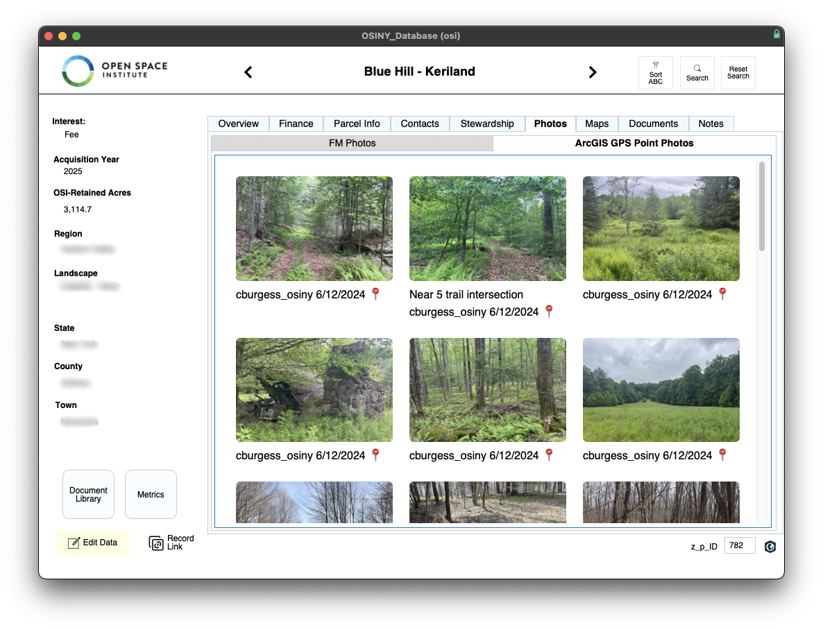
Project features and attribute tables in AGOL now have clickable links or buttons to access corresponding records in FileMaker. Photos that are captured in the field using the ArcGIS Field Maps mobile app now automatically display in FileMaker.
Visualizing Data Holistically
Users can now store and edit spatial and non-spatial data in the same systems and instantly access related FileMaker data, documents (stored in a FileMaker document library), and reports. This capability is invaluable for comprehensive project understanding and archival requirements.
Empowering Accreditation
The integrated data, documents, and mapping capabilities within FileMaker are directly utilized in OSI’s rigorous accreditation process, providing a transparent and comprehensive view to accreditation committees.
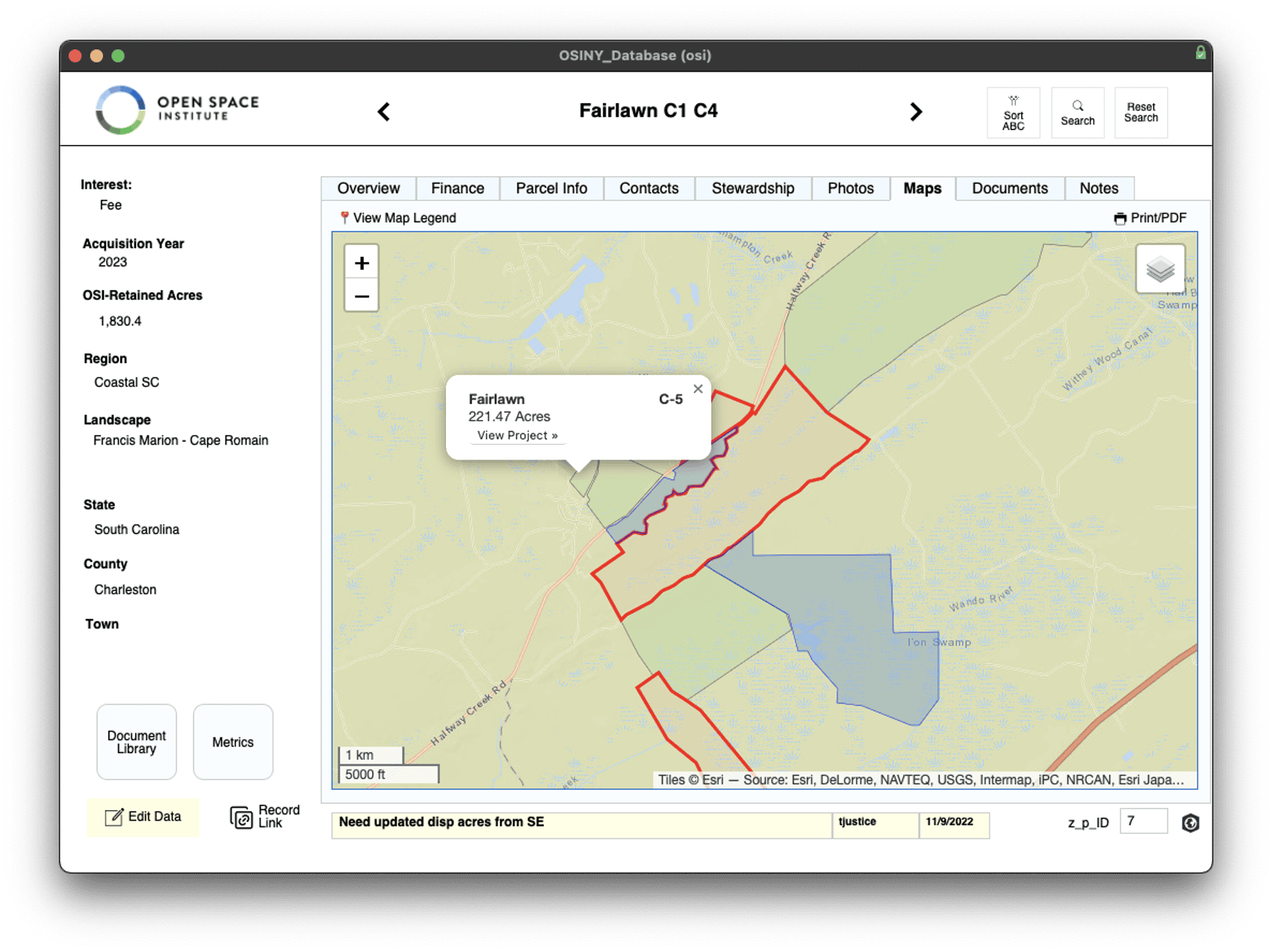
Enabling Maps in FileMaker
Interactive maps similar to what ArcGIS users see are rendered natively in WebViewers using the very same data. These maps can be used to navigate in FileMaker too, for example clicking an adjacent property on the map will take you to that property’s project record.
Mapping Enhancements
- Dynamically displayed layers depending on project type – highlighting the relevant data based on context.
- Popups on features that show all attribute data or data customized by user defined templates with merge fields.
- Styles based on attributes tracked in ArcGIS or FileMaker (e.g. a blue property is a “Historical” holding that is no longer active in OSI’s portfolio).
- Print, PDF, and Web Direct compatibility – maps can be exported, in any state, with interactive controls (e.g. zoom and layer selectors) removed as JPGs or PDFs for archival purposes.
- Tabloid sized maps for print that use higher resolution basemaps for improved image quality.
- Legends that pull symbology directly from ArcGIS domains and adjust content dynamically based on which map layers are enabled by the user.
- Support for all Esri basemaps including satellite imagery and Nearmap aerial imagery and Regrid parcel data.
- Photos captured at monitoring points in the field using ArcGIS apps automatically appear in FileMaker and can be viewed as thumbnails, a slideshow, or even on the existing project maps.
A Blueprint for Success
OSI’s collaboration with LuminFire extended beyond technical implementation. It was a holistic partnership that optimized their entire technology ecosystem, enabling them to be more effective and productive in their vital conservation work. This included:
- Cost Optimization: Expert evaluation of their FileMaker licensing led to significant cost savings – for 23% less annually, they now have licenses for all staff and WebDirect users versus a limited number of concurrent connections.
- Future-Proofing: Upgrading to the latest FileMaker version ensures their solution remains secure, robust, and able to leverage the latest features in the FileMaker platform.
- Managed Cloud Hosting: Moving to private cloud hosting ensures ongoing data accessibility and protection as well as supporting future integrations.
- Enhanced Capabilities: The integration with ArcGIS Online dramatically expanded their analytical and operational capabilities.
OSI’s solution powerfully demonstrates the transformative potential of custom technology. Their success, driven by Claris FileMaker and expertly enhanced by LuminFire, highlights how a tailored approach to data management can dramatically boost efficiency and directly advance an organization’s vital mission. Through strategic investment and a strong partnership, OSI continues to lead the charge in land preservation, fueled by technology that truly empowers their impact.
Is your organization ready to transform its data management and unlock new levels of efficiency? LuminFire can help.

Tim Cimbura – CEO, CFO and Solution Engineer
Tim is an expert in creating custom business solutions that make businesses more effective, productive, and profitable. He specializes in rapid application development with Claris FileMaker, Laravel, and WordPress. He also knows Apple macOS technology inside and out.